Room 01 · Museum of Seattle
Alki
Seattle often begins its story with twenty-two settlers stepping ashore at Alki in 1851. The place they entered already had names, uses, homes, and graves.
A way into this room
A landing is an arrival, and an arrival means there was already a place to arrive in. The Denny Party stepped onto Duwamish land that carried a name, sustained communities, and held a burial ground.
Fourteen years later, the town the settlers founded passed an ordinance excluding Native people from much of Seattle. The record was never entirely hidden. We simply learned to begin reading it too late.
Before the count
The place, the people, and the shoreline — none of which begin in 1851.
Prairie point
Alki Point carries a Southern Lushootseed name recorded as sbaqwabqs, given as "prairie point." The spelling here follows the cited source exactly.
Lushootseed orthography is specialist work. We have not embellished or regularised the name, and we have not yet confirmed this rendering against the Burke Museum Waterlines Project or with a Lushootseed specialist.
Sources
- ReferenceHistoryLink Essay 3428 — Seattle Neighborhoods: West Seattle — Thumbnail History— spelled "sbaqwabqs" in the section "By and By"
- SecondaryBurke Museum — Waterlines Project Map
Checked July 25, 2026 — with a caveat
Spelling follows HistoryLink and is pending review against Lushootseed scholarship. Treat as provisional.
Seventeen villages
When the Denny Party arrived there were at least seventeen Duwamish and Suquamish villages around Puget Sound. On the West Seattle peninsula, one archaeological site has produced material dating to the sixth century.
The point where the party came ashore had long been used as a Duwamish burial ground.
These are not details outside the landing story. They describe the place in which the landing occurred.
Sources
- ReferenceHistoryLink Essay 3428 — Seattle Neighborhoods: West Seattle — Thumbnail History— "at least 17 Duwamish and Suquamish villages"; "had long been used as a Duwamish burial site"
- Tribal sourceDuwamish Tribe — official site
Checked against the cited sources on July 25, 2026.
The shoreline is not where you are standing
The beach at Alki has been seawalled, filled and regraded. To see the shore the Duwamish used and the Denny Party landed on, you need a chart drawn before the city.
The US Coast Survey mapped Duwamish Bay in 1854 — one year before the Treaty of Point Elliott, three years after the landing. It is the earliest detailed picture of this water we can put on a wall, and it is in the public domain.
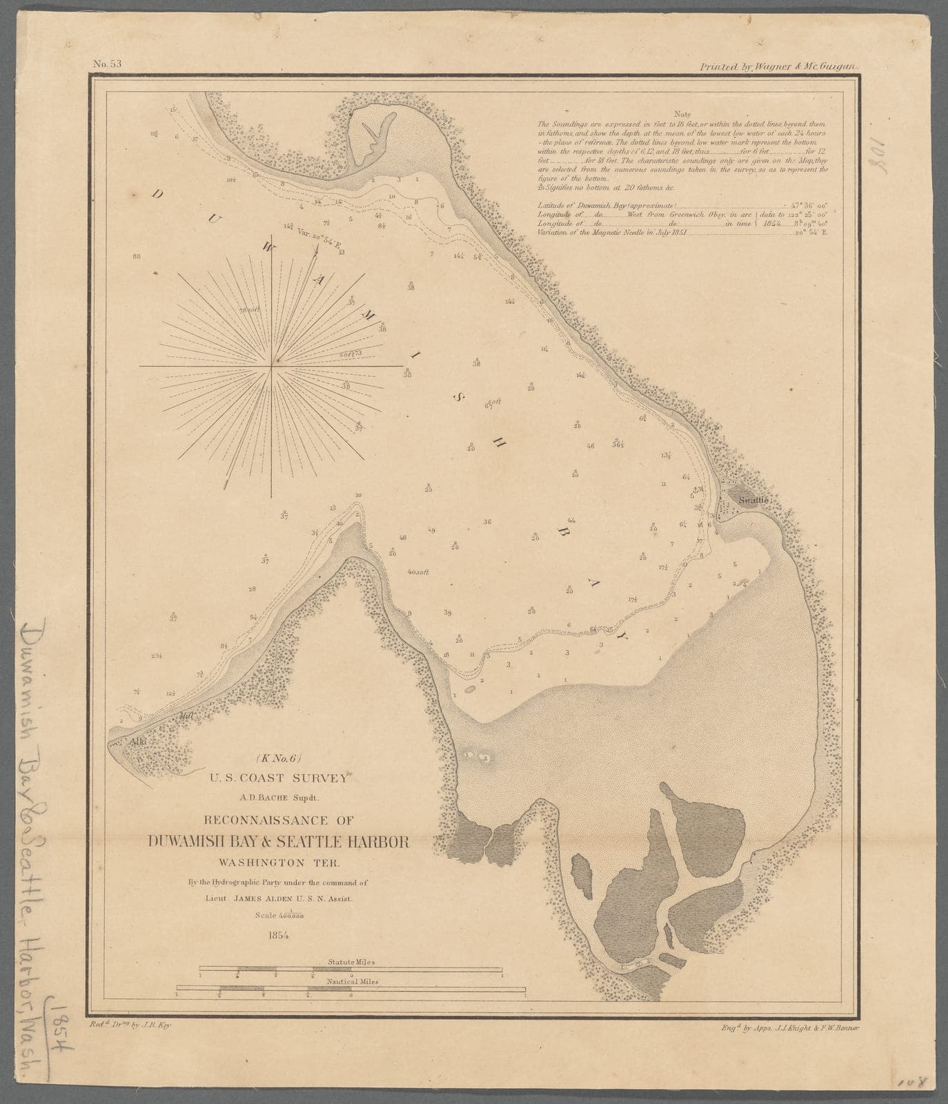
Alki Point is at the lower left, Seattle a note on the far shore, and the mouth of the Duwamish is a broad shaded tideflat — the shoreline the Duwamish used and the Denny Party landed on, drawn the year before the Treaty of Point Elliott and long before any of it was filled.
New York Public Library, Lionel Pincus & Princess Firyal Map Division. Surveyed by the hydrographic party under Lieut. James Alden, U.S.N. · Public domain in the United States. NYPL recommends but does not require credit.
Sources
- PrimaryReconnaissance of Duwamish Bay & Seattle Harbor, Washington Ter. (US Coast Survey, 1854)— New York Public Library, Lionel Pincus & Princess Firyal Map Division
- SecondaryBurke Museum — Waterlines Project Map
Checked against the cited sources on July 25, 2026.
The landing
13 November 1851, and the winter that followed.
The schooner Exact
Scouts had come first. On 25 September 1851 David Denny, John Low and Lee Terry reached the mouth of the Duwamish River, camped near an Indian village at Duwamish Head, and met Chief Seattle. On 28 September Low and Terry staked Donation Land Claims at Alki Point.
On 13 November the schooner Exact put ten adults and twelve children ashore — twenty-two people, joining the two already there. The cabin waiting for them had no roof. It was raining. The women, by the account of one of the men, "sat down on the loggs and took A Big Cry."
They named the place New York. Charles Terry platted it under the name Alki — Chinook Jargon for "by and by" — on 28 May 1853.
See the landing site on the map“[O]ur goods and chattles were sent ashore at near low tid on 13 of Nov 1851 near Noon. The Women and children of our party set to work to help get them above high tide then the ladys sat down on the loggs and took A Big Cry”
Sources
- ReferenceHistoryLink Essay 5392 — Denny Party lands at Alki Point, November 13, 1851— "ten other adults, and 12 children"; Bell quotation
- ReferenceHistoryLink Essay 5391 — Denny Party scouts arrive at mouth of Duwamish River, September 25, 1851
- ReferenceHistoryLink Essay 3428 — Seattle Neighborhoods: West Seattle — Thumbnail History— Terry platted and renamed the town on May 28, 1853
- PrimaryArthur A. Denny, Pioneer Days on Puget Sound (1888; 1908 ed.)— p. 38 — Denny counts twenty-four persons present, twelve adults and twelve children, including the two already ashore
Checked against the cited sources on July 25, 2026.
Who fed whom
The Duwamish, in HistoryLink's words, "willingly provided the struggling newcomers with fish and other survival basics." At Alki that first winter, food supplies ran low and several of the party fell sick.
Arthur Denny remembered the first winter as mild. The deeper hunger came in 1852–53, when the settlers lost their pork to the tide and exhausted their flour, hard bread, and potatoes. They crossed the water by canoe to a Native settlement on the Black River for food.
“We then had to make a canoe voyage to the Indian settlement on Black river to get a fresh stock of potatoes.”
Sources
- PrimaryArthur A. Denny, Pioneer Days on Puget Sound (1888; 1908 ed.)— pp. 54–55 (Black River potatoes); p. 89 ("pinching want"); p. 96 (the first winter was mild)
- ReferenceHistoryLink Essay 8894 — Duwamish Tribe celebrates new Longhouse, January 3, 2009— "willingly provided the struggling newcomers with fish and other survival basics"
- ReferenceHistoryLink Essay 3428 — Seattle Neighborhoods: West Seattle — Thumbnail History— "food supplies ran low, and several members of the party fell sick"
Checked against the cited sources on July 25, 2026.
They were never going to stay
Alki is exposed. Within weeks Arthur Denny, Carson Boren and William Bell were sounding Elliott Bay for a deeper harbour; they marked claims on its eastern shore on 15 February 1852 and most of the party had moved by mid-April.
It is tempting to read this as failure, and Alki has worn that reading for a century. The record is plainer: Boren, Denny and Bell "did not intend to settle at Alki Point; rather they used Alki as their base" while they looked for claims. The move was the plan.
Sources
- ReferenceHistoryLink Essay 303 — Seattle — A Brief History of Its Founding— claims marked February 15, 1852; relocation by mid-April
- ReferenceHistoryLink Essay 7045 — Seattle's Early Donation Land Claims— "did not intend to settle at Alki Point; rather they used Alki as their base"
- ReferenceHistoryLink Essay 4197 — Alki Point Light Station— Terry sold the 320-acre claim to Maynard in 1857
Checked against the cited sources on July 25, 2026.
Title, treaty, ordinance
How the ground under this map changed hands, in the order it actually happened.
Treaty of Point Elliott
At Muckl-te-oh, Governor Isaac Stevens and leaders of the Duwamish, Suquamish, Snoqualmie, Lummi, and other tribes and bands signed the Treaty of Point Elliott. The treaty ceded title to the land on which Seattle stands while reserving payments, services, and the right of "taking fish at usual and accustomed grounds and stations."
Congress took four years to ratify it. Some of what was promised in it has still not been delivered.
The full treaty is linked below so its language can be read directly.
Sources
- PrimaryTreaty of Point Elliott, 12 Stat. 927— US Government work — public domain
- Tribal sourceDuwamish Tribe — Treaty of Point Elliott
- ReferenceHistoryLink Essay 2629 — Treaty of Point Elliott, 1855 — full transcription
Checked against the cited sources on July 25, 2026.
Ordinance No. 5
Ten years after the treaty and six after its ratification, the Board of Trustees of the Town of Seattle passed its fifth ordinance. Section one barred any "Indian or Indians" from residing on any street, alley or vacant lot between stated bounds. Section two required anyone employing Native people to house them on their own property.
Read together: Native people could not live in Seattle unless a settler needed them to.
The ordinance was never repealed. Seattle's government was dissolved in 1867 at the request of its own residents, and when the town reincorporated in 1869 the ban was simply not re-enacted. Exclusion continued by other means — including the burning of the Duwamish winter village Herring's House in 1893.
“That no Indian or Indians shall be permitted to reside, or locate their residences on any street, highway, lane, or alley or any vacant lot in the town of Seattle…”
Sources
- ReferenceHistoryLink Essay 10979 — Seattle Board of Trustees passes ordinance calling for removal of Indians, February 7, 1865— text of §1 and §2; dissolution 1867, reincorporation 1869; Herring's House 1893
- SecondaryKing County Council — Native American Expulsion Remembrance Day (2015)
Checked against the cited sources on July 25, 2026.
The claims that drew the lot lines
The Donation Land Claim Act of 1850 opened Oregon Territory to settler claims while acknowledging that Indigenous title first had to be extinguished by treaty. Low and Lee Terry staked claims at Alki in September 1851; Denny, Boren, and Bell claimed the eastern shore of Elliott Bay in February 1852.
All of those claims were staked before the Treaty of Point Elliott was signed in 1855 and ratified in 1859.
Those claims became some of Seattle's earliest survey lines, with later plats laid over them. Open today's parcel map and you are reading boundaries whose oldest ancestors include claims filed with the General Land Office before the treaty.
The paperwork is incomplete: the claim papers of both Lee Terry and John Low are not extant.
Sources
- ReferenceHistoryLink Essay 7045 — Seattle's Early Donation Land Claims— claim-by-claim summary; papers of Lee Terry and John Low not extant
- ReferenceHistoryLink Essay 10979 — Seattle Board of Trustees passes ordinance…— "this did not prevent members of the Denny Party … from claiming land along the shore of Elliott Bay in 1852"
- ReferenceHistoryLink Essay 3142 — Charles Terry homesteads site of Alki business district, May 1, 1852
- ReferenceHistoryLink Essay 400 — Donation Land Law, also known as the Oregon Land Law
Checked July 25, 2026 — with a caveat
Sourced from HistoryLink's claim summary. The underlying BLM General Land Office patent records have not yet been retrieved — their search API now requires an authenticated session.
A beach remade for leisure
As Alki became Seattle's playground, a different public memory settled over the shore.
Luna Park
Built on pilings over the tideflats, Luna Park offered a roller coaster, natatorium, dance hall, and bar. It helped prompt West Seattle's annexation to Seattle, closed in 1913, and burned in 1931. At the lowest tides its pilings still emerge—a shoreline briefly remade for amusement.
Sources
- ReferenceHistoryLink Essay 1390 — Luna Park — the Coney Island of the West (1907–1913)— annexation vote 325 to 8; natatorium arson April 14, 1931
- SecondarySouthwest Seattle Historical Society / Log House Museum — Luna Park
Checked against the cited sources on July 25, 2026.
The light
A local legend says farmer Hans Martin Hanson hung a kerosene lantern on his barn in the 1870s to mark the shoals. What is documented is an official post lantern installed in 1887 and tended first by Hanson and then by his son Edmund.
The present station opened in 1913: a thirty-seven-foot octagonal tower with a fourth-order Fresnel lens and a three-trumpet fog signal.
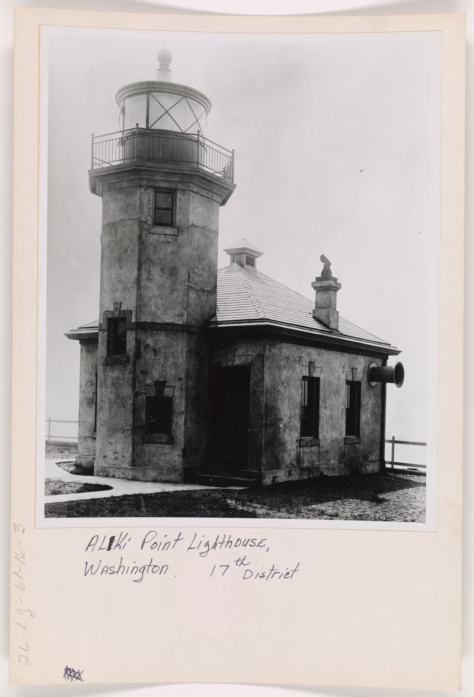
The station as the Lighthouse Service photographed it: the thirty-seven-foot octagonal tower and, projecting from the wall at right, one of the three Daboll trumpets that threw the fog signal north, south and west.
National Archives, Records of the U.S. Coast Guard (RG 26), Lighthouses series · US Government work. NARA records use and access as Unrestricted.
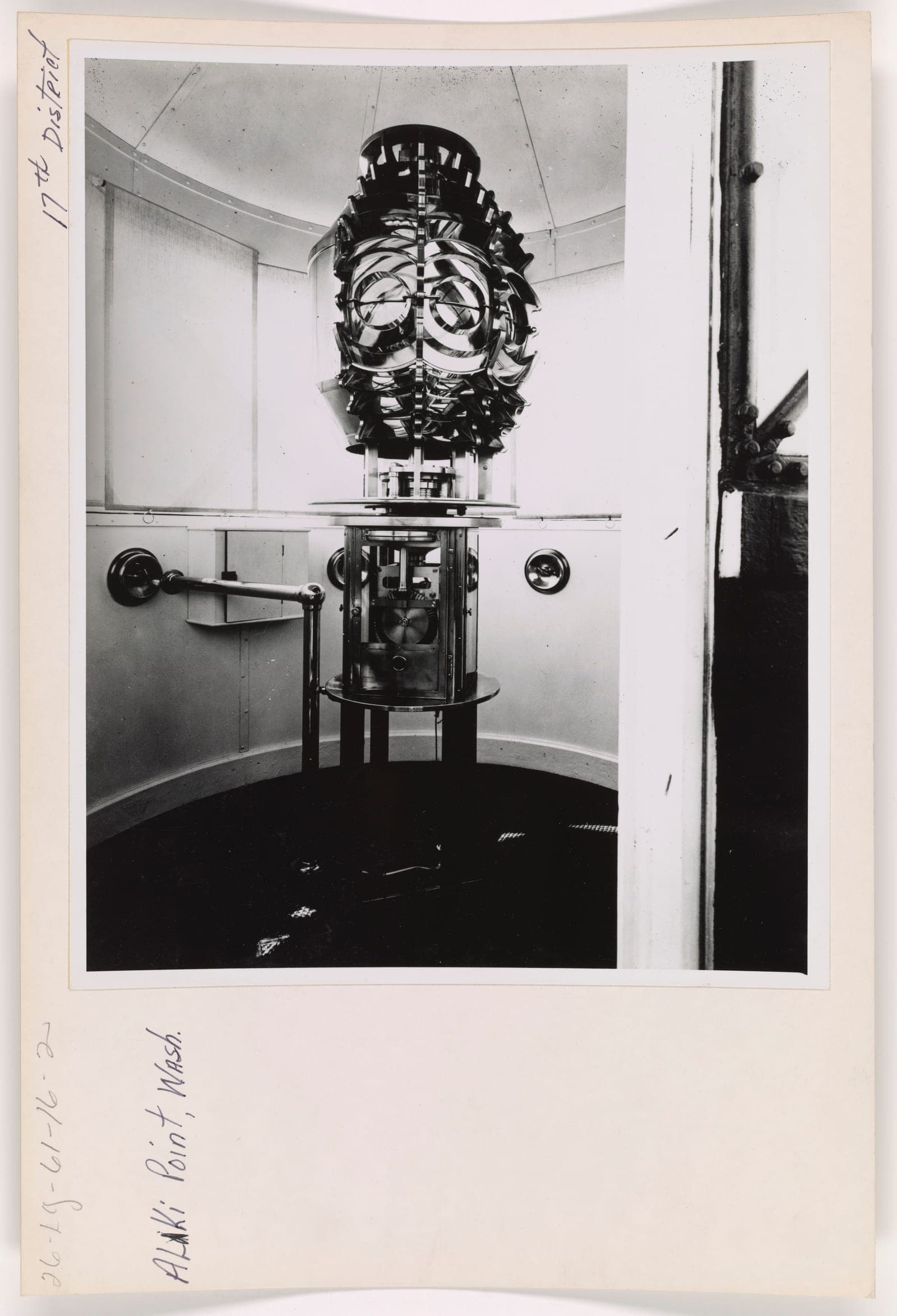
The fourth-order Fresnel lens in the lantern room, standing on the clockwork that turned it. A keeper wound the weights back to the top of the tower several times a night to keep the light revolving.
National Archives, Records of the U.S. Coast Guard (RG 26), Lighthouses series · US Government work. NARA records use and access as Unrestricted.
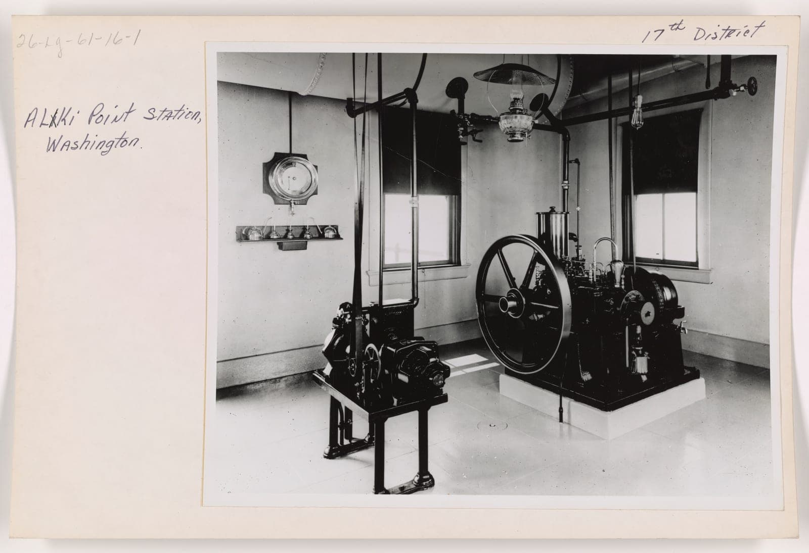
The engine room. Two engines produced the compressed air that was driven across a vibrating reed to make the fog signal — the least romantic and most used machinery on the point.
National Archives, Records of the U.S. Coast Guard (RG 26), Lighthouses series · US Government work. NARA records use and access as Unrestricted.
Sources
- ReferenceHistoryLink Essay 4197 — Alki Point Light Station— "According to legend" (twice); 1887 post lantern; $15/month; opened April 1, 1913
- PrimaryUS Coast Guard, Lighthouses series — Alki Point (Record Group 26)— National Archives; use and access both recorded as Unrestricted
Checked against the cited sources on July 25, 2026.
Bathhouse and summer home
In the early twentieth century, bathhouses, ferries, streetcars, and seasonal cottages turned Alki into a summer address. Seattle Public Library photographs show both the leisure and the increasingly engineered shore: a homeland and landing place recast as a city beach.
Sources
- PrimarySeattle Public Library — Seattle Historical Photograph Collection (Alki bathhouse, bathers, summer homes, 1906–1915)— Rights vary by item; SPL asks users to make their own copyright assessment
Checked July 25, 2026 — with a caveat
Images identified but not yet published here. SPL's item pages state a narrower permission than the aggregated rights metadata suggests; we are seeking written confirmation before displaying them.
What gets remembered
Two monuments, one longhouse, and an argument that is still running.
The Longhouse, and recognition
The Duwamish Longhouse and Cultural Center opened at 4705 West Marginal Way SW, on a traditional riverside village site, after more than three decades of planning and fundraising by a tribe of about 570 members.
The Duwamish are not federally recognized. The tribe received acknowledgement in 2001 under the Clinton administration; by its own account that decision "was reversed in 2002" under the Bush administration. In March 2013 a federal judge found the denial arbitrary and capricious and ordered reconsideration; Interior denied recognition again in 2015. The tribe sued the Department of the Interior on 11 May 2022 and describes its case as still pending.
Federal recognition remains a live matter. The verification date below marks when this account was last checked.
Sources
- Tribal sourceDuwamish Tribe — Federal Acknowledgement— "We received acknowledgement in 2001… reversed in 2002"; case pending before the Interior Board of Indian Appeals
- Tribal sourceDuwamish Tribe — Lawsuit for Federal Recognition
- ReferenceHistoryLink Essay 8894 — Duwamish Tribe celebrates new Longhouse and Cultural Center, January 3, 2009— 4705 West Marginal Way SW; 570 members; $4 million
Checked July 25, 2026 — with a caveat
Recognition proceedings are ongoing and this panel can go out of date without warning. Re-check the tribe's own pages before relying on it.
And Wife
The shaft lists the men by name. The married women of the party are cut into the stone as "And Wife." They waited until the 2001 sesquicentennial for a plaque of their own.
In 1926 the monument was rebuilt on a new foundation, and a stone carried west by the First Transcontinental Motorized Caravan was set into it under a tablet reading "From Plymouth Rock to Alki Point." A replica Statue of Liberty joined the beach in 1952. Alki has never been short of ways to compare itself to somewhere else.
Sources
- ReferenceHistoryLink Essay 3917 — Seattle celebrates its 54th birthday and dedicates the Alki Point monument, November 13, 1905— six unveilers; "And Wife"; addendum plaque at the 2001 sesquicentennial
- Primary"From Plymouth Rock to Alki Point" — monument tablet, rededicated 4 September 1926— Tablet furnished by the Automobile Club of Washington
Checked July 25, 2026 — with a caveat
The 1926 Plymouth Rock stone is sourced to the monument's own tablet — evidence of the claim, not yet of the fact. The 1952 Statue of Liberty dates are not independently checked.
How we know this—and what remains uncertain
This room was written by non-Native authors and has not been reviewed by the Duwamish Tribe. Lushootseed spellings follow the cited sources and remain pending specialist review. We do not display historical photographs of identifiable Native individuals without clearer guidance on their use. Corrections and better sources are welcome.